Flooding and Sea Level Rise in Petaluma

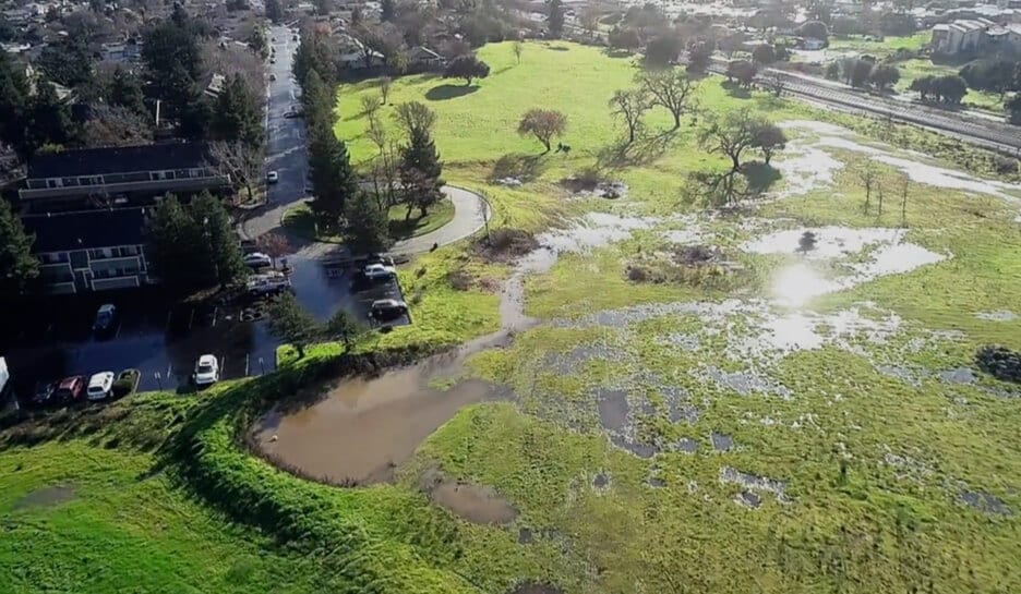
A Photograph of the Sid Commons 180 Unit Housing Site
Petaluma is a river town (or more accurately a slough city). Our town has alternated between relying on the river for its existence to literally turning its back to the river (I’m looking at you Golden Eagle Shopping Center). When I founded my gallery in 2007, I named it “Riverfront Art Gallery” to emphasize the importance and uniqueness of having a river run through our town.
One side effect of having a river in town is flooding, and with the lower Petaluma River being a slough, we will be affected by rising sea levels. Flood danger is now worse since the entire eastside was an alluvial flood plain and historic wetland. When it was developed into subdivisions, the creeks were confined to flood channels that run directly to the river. Very little of our original riparian habitat is intact, and what little is left is under continual threat of bad development decisions made by our city.
Background on Flooding
In 1982 the Payran neighborhood flooded, and water swept over 50 blocks and into 500 homes. The damage reached $28 million. The floods of 1986 caused more damage and, in 1998, the river caused another $6 million in damage.
In 1988 work began on a $41 million project to build a flood wall along 3,600 feet of the river’s bank, and a weir was constructed on the upper Petaluma River. It was finally completed in 2016. The weir and flood wall have protected our town well so far, but the U.S. Army Corps of Engineers warned that no development should occur upstream of the weir. The land upstream of the weir (called the Corona Reach) was zoned agricultural, so there was little danger of construction there. This land has stayed largely intact since Europeans first arrived. It is a hidden gem that many Petalumans don’t know about.
In 1991, the city approved the construction of an outlet mall in part of the Corona Reach. The city said that there was no danger of flooding, and the outlet mall was built. On December 31, 2005, the city experienced significant flooding in the Corona Reach. It is estimated that approximately 53 structures were damaged by floodwaters at an approximate cost of $56 million dollars. The Outlet Mall was inundated by this flood, and so was the auto mall.
Not only does this area flood, but the Corona Reach also provides much needed protection from flooding downstream. This riparian area with meadows and wetlands absorbs a ton of water before it reaches the weir. If it is paved over, that water will be shunted to the downtown and Payran areas. Certain parcels near there are “high-hazard zones” that are in danger of flooding, and property owners are required to buy flood insurance that can cost over $2,000 a year, so there is a cost to Petalumans when inappropriate development puts more parcels in these zones.
Flood Management
One of the tools a city uses to model flooding are “Flood Maps”. About 3 years ago, FEMA allowed local flood modeling and mapping to take into account prospective flood levels and frequencies. Prior to that change of rules, local entities and their hydrological consultants could legally only base their models on retrospective data – i.e., what has happened before. Now prospective modeling, including climate change, is allowed but not mandated.
Petaluma has chosen not to use prospective modeling upstream of the weir, instead limiting calcs and modeling only to sea level rise impacts below the weir. That means no changes in rainfall, runoff, ponding, flood elevations, or in the role of the huge natural storage basin in Denman Flats are factored in to what are now accepted and expected climate change predictions in the upper Petaluma River basin.
If our city continues to ignore climate change impacts on flooding in the upper Petaluma River watershed, poor planning decisions will be made, and people will not be well informed about the risks they face and the flood insurance they should have.
Predictions based on prospective flood levels and frequencies are now being distributed by the First Street Foundation and are being incorporated into property disclosures through Zillow. If you want to see the risk for your address, go here https://firststreet.org/?from=riskfactor.com You can also find out about other risk factors for your address at this website.
Sid Commons (a tragedy brought to you by Mike Healy and Kevin McDonnell)
Sid Commons couldn’t be built because that parcel was zoned agricultural. All members of the Planning Commission unanimously voted not to change the zoning when asked by the Johnsons (the owners of the property). Kevin McDonnell, the city council’s liaison, was the sole vote for re-zoning. At city council, Kevin McDonnell, Mike Healy, and Healy’s allies voted to override the Planning Commission’s recommendations and approved a re-zoning of the Johnson’s parcel so that the Sid Commons development could be approved.
The Sid Commons site is a wetland, and there is only one narrow road for entry and egress. The city’s “biologist” said hardly any species would be impacted by this 180-unit housing complex. However, a nationally-recognized biological expert hired by concerned Petaluma residents determined that at least a dozen native species would lose habitat.
The development would require extensive bulldozing and grading, and the Johnsons will need to terrace the riverbank to shunt floodwaters downstream (to the Payran and Downtown districts). A group of private Petaluma citizens sued over this development and, to date, ground has not yet been broken for this project.
The Johnsons now have a proposal to build 600 more homes on the other side of the Petaluma River, in the Corona Reach, with over 1100 parking spaces. You can see those proposals here https://cityofpetaluma.org/deer-creek-1-spar-application-for-559-dwellings/ and here https://cityofpetaluma.org/deer-creek-2-spar/
Sid Commons should never have been approved by our city council.
Rainier Connector
The “Rainier Connector” would be constructed in this same flood plain. This is a very expensive undertaking. Mike Healy claims we could do an inexpensive two-lane road at ground level. First of all, a two-lane road would do little to alleviate traffic congestion and, second, the only purpose of a two-lane road would be to help the Johnsons and other large property owners in this area open up the Corona Reach for intensive development. If that happens, we can forget about our flood wall protecting us from any further flooding.
The Rainier Connector would have to be an elevated highway (going over the railroad tracks and river), costing well above $110 million dollars, and it would be paid for by Petaluma taxpayers – since this is a local road and not a state or federal highway. SmartTrain has said they won’t allow a ground level rail crossing, and CalTrans has said there can be no off ramps at Rainier since it is too close to other off ramps.
This connector would destroy the largest remaining riparian habitat in our city limits, cause extensive flooding downstream, and would require many more property owners to obtain flood insurance.
What Should be done in the Corona Reach?
The Corona Reach should be turned into a grand central park with low impact facilities, and all the open land there should be restored to its natural state. New native trees and plants would reduce freeway noise in town while providing habitat to native species. It would also help protect us from catastrophic flooding. And finally, it could become a carbon-free, crosstown connector for hiking and biking only.
Your vote matters!
Lance

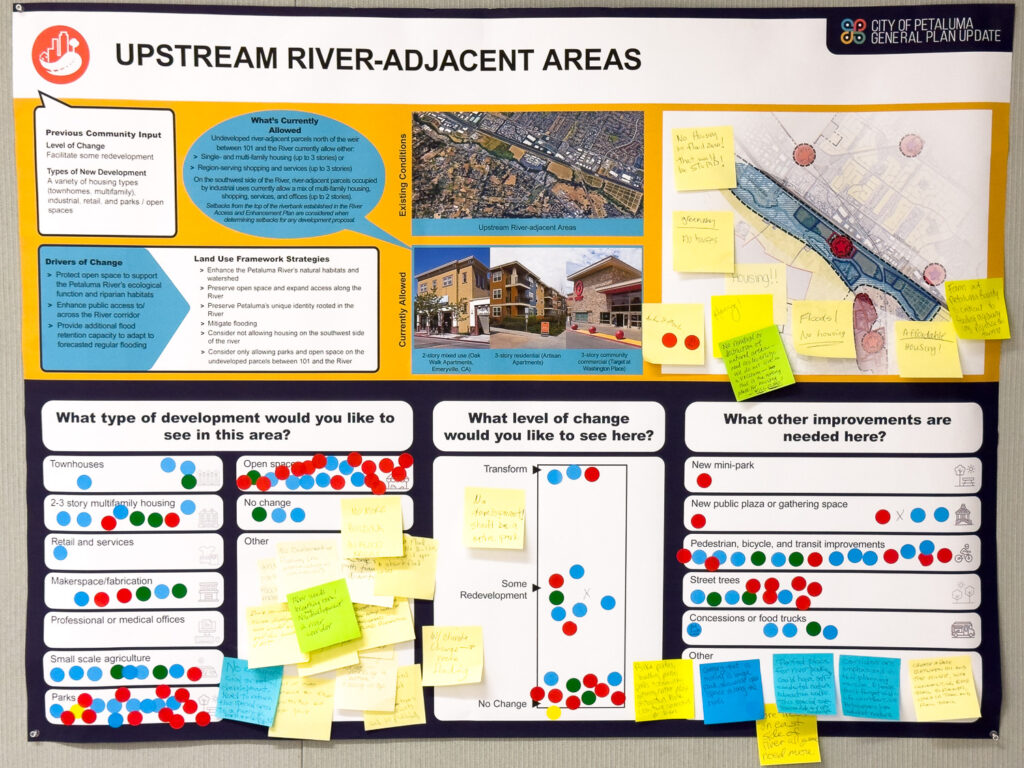
A Poster at the Recent “Open House” put on by our “Planning Department” on September 25th, asking if we should do intensive development in the Corona Reach.
(such as 3-story residential buildings or stores like Target)
They stupidly asked the same thing about the Outlet Mall location as well.
What Should be done about Rising Sea Levels?
We shouldn’t put another piece of infrastructure in any area that would flood within the next 100 years. These undeveloped spaces should be restored to their natural state in consultation with expert biologists, and I think that some of these areas should become low-impact hiking and biking paths.
Your vote matters!
Lance
An Endorsement from a District 6 Voter
“Long time Petaluman and I stand with what he believes in.”
If you support my campaign, send me a message and tell me why. I may quote you in a future newsletter.
To help spread the message of this campaign, consider getting a yard sign and/or making a donation. I am running against two incumbents simultaneously, and changing how our city is run isn’t easy.
Brian Barnacle’s campaign has way more money than mine, and he attacks me regularly with baseless accusations instead of defending his positions. A little more funding for my campaign would go a long way.
Please click the Facebook and/or Instagram links below to follow my campaign. If I get enough followers, I will make posts to those accounts on a more regular basis.